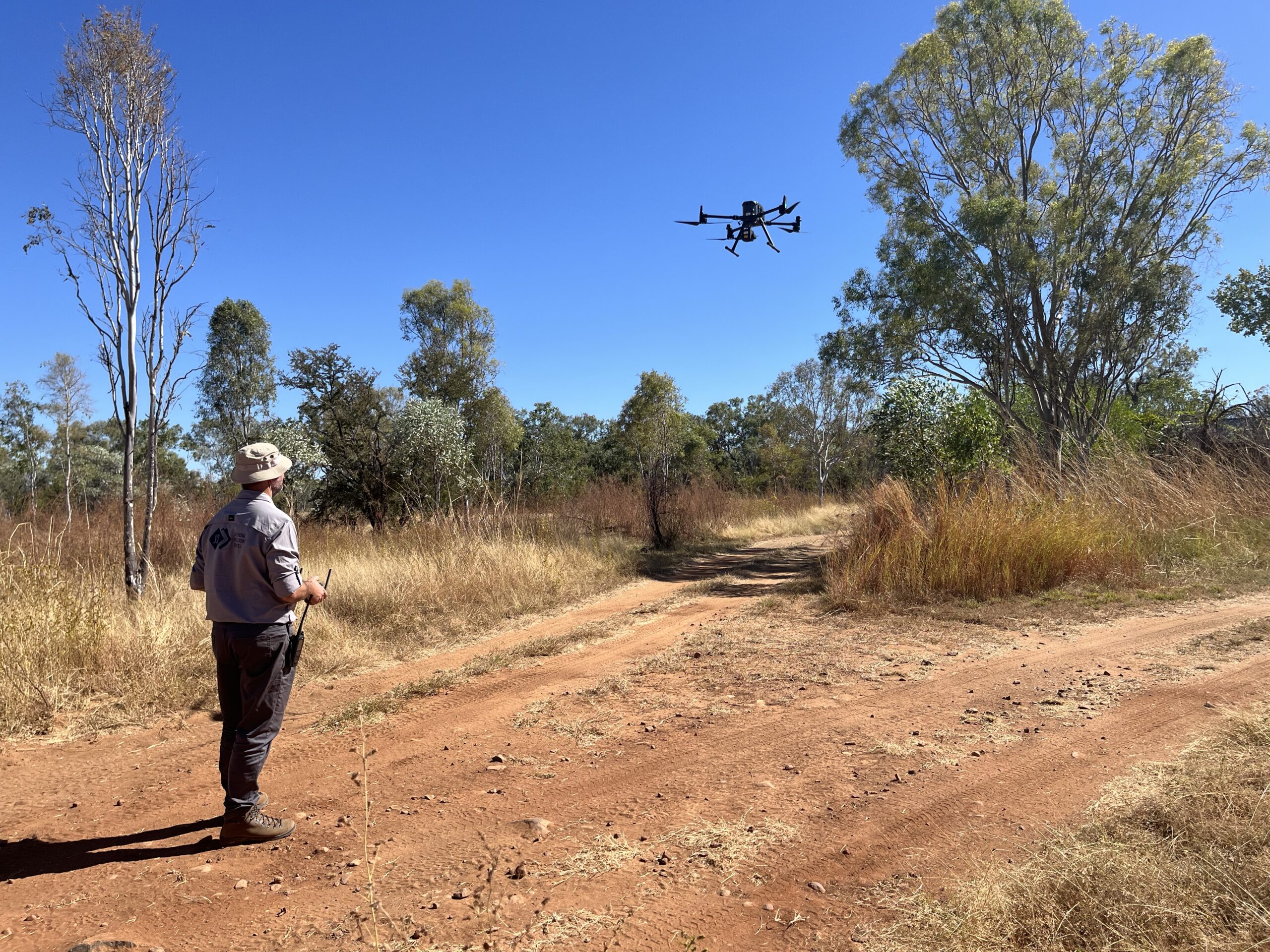
J2’s inspections service integrates advanced aerial and ground-based technologies, including colour photogrammetry, thermal photogrammetry, and LiDAR imagery processing, to offer high-resolution 2D and 3D mapping of assets.
This comprehensive approach provides detailed visual and thermal analyses, enabling precise asset monitoring and terrain assessment. Ideal for maintenance and environmental evaluations, our service ensures accurate and efficient asset management intelligence.

-
Asset inspections – RGB
High resolution aerial and ground-based 2D and 3D mapping of assets using colour photogrammetry.
-
Asset inspections – thermal
High resolution aerial thermal mapping of assets using thermal photogrammetry
-
Asset inspections – LiDAR
High resolution aerial 2D and 3D mapping of assets using LiDAR imagery processing.
-
Ground-based modelling and inspections
J2 integrates ground-based sensors to provide additional insight through first-person perspective and real-time imagery feeds
360° camera human-mounted
360° street view vehicle-mounted sensors
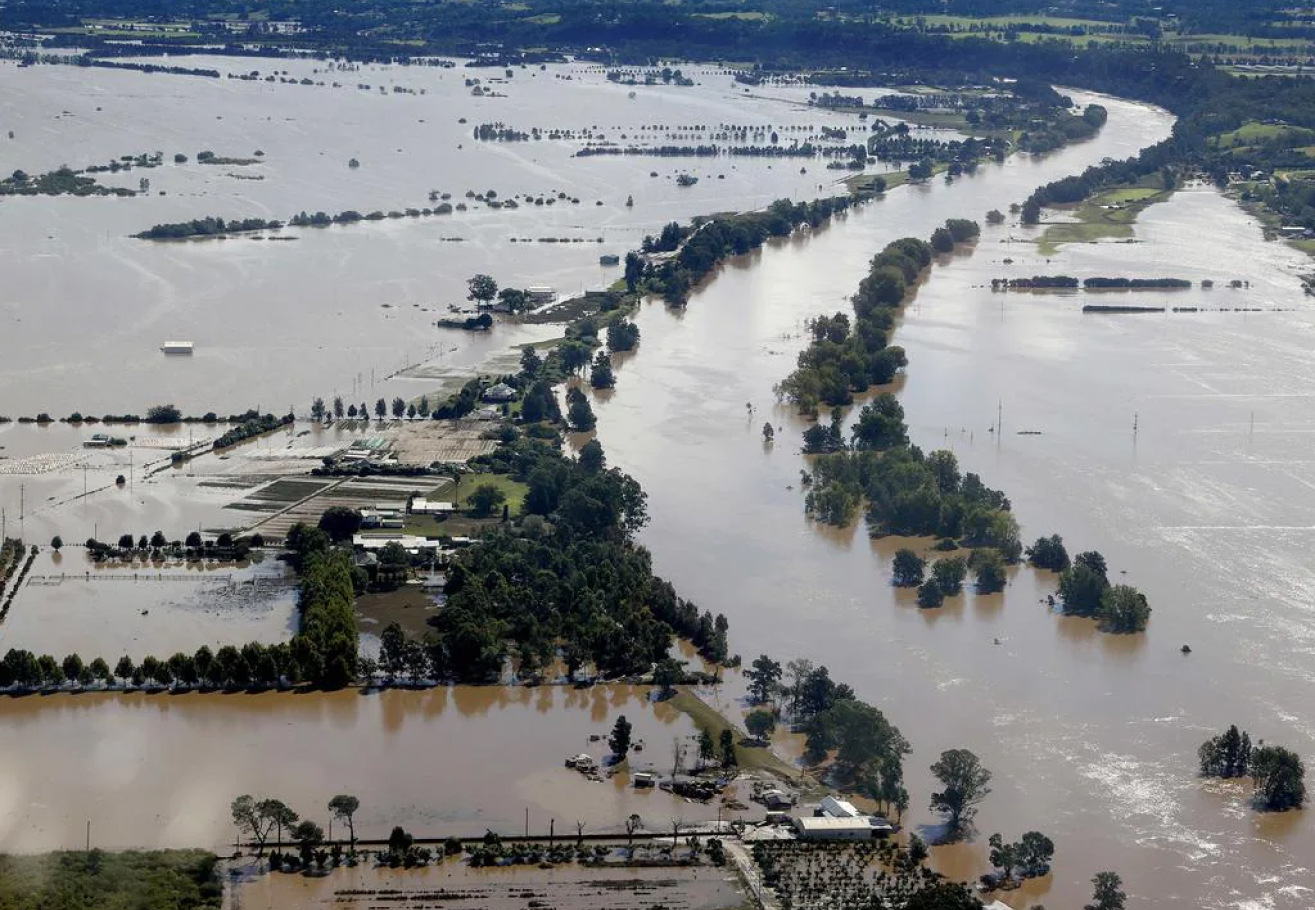
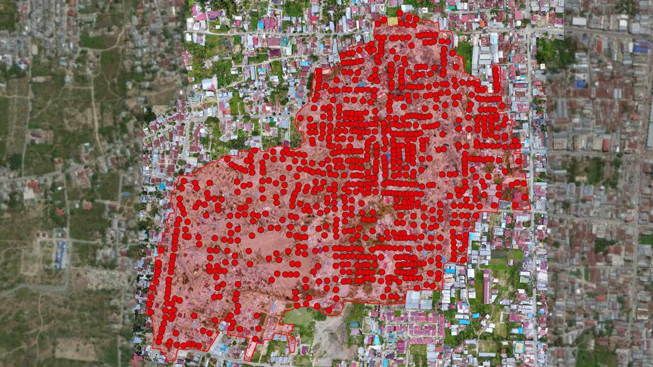
J2’s integrated inspection services employ high-resolution photogrammetry for thorough pre and post-disaster damage assessments, from aerial views to ground-level ‘streetview’ imaging, mirroring real estate walkthroughs for impact analysis. We ensure rapid response with drone teams and AI-supported analysis for swift and precise intelligence reports. Specialised in supporting military and humanitarian missions, our self-sufficient reconnaissance teams excel in remote operations, delivering advanced intelligence support and comprehensive visual documentation.
-
Damage assessments – disaster
Post disaster aerial damage assessments using high resolution photogrammetry
-
Damage assessments – insurance
Pre and post impact, aerial and ground-based damage assessments using high resolution photogrammetry
-
Damage assessments – ground-based 360 degree walkthrough
Ground-based “Streetview” photogrammetry, equivalent to real estate walkthrough imagery for impact assessment
-
Rapid damage assessment and intelligence provision – post disaster
Rapid deployment of drone teams and analysts to collect imagery and information, process data and produce damage and impact intelligence reports and products, post disaster.
-
Field and remote reconnaissance: disaster, humanitarian and other
Military, small teams reconnaissance concepts applied for post disaster impact assessments, humanitarian aid pre-planning and other scenarios that require advanced, Intelligence, Reconnaissance and Surveillance (ISR) support. Self-sufficient teams with the ability to operate and report/communicate in remote environments, capturing aerial and ground-based imagery and observations.
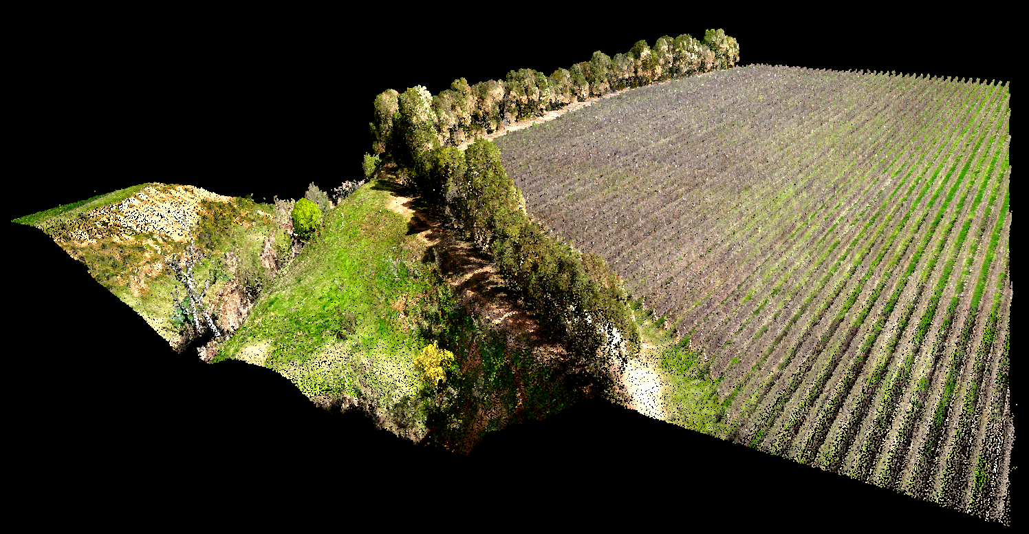
Utilising advanced aerial photogrammetry and spatial data sources, J2’s 2D and 3D mapping services provide precise representations of terrain and infrastructure, vital for risk assessment and strategic planning. Our integrated aerial and ground-based capabilities deliver accurate temporal snapshots for progress monitoring and reporting. We ensure impeccable accuracy through survey-grade, GPS-calibrated mapping, and comply with CASA BVLOS approvals for large-scale initiatives.
-
Resilience – hazard exposure mapping
High resolution aerial 2D and 3D mapping of terrain and infrastructure using photogrammetry and other spatial data sources to provide a spatial representation of the natural terrain and analysis of historical data and modelled scenarios to determine the level of exposure and risk of various areas to a variety of hazards.
-
Critical infrastructure mapping
High resolution aerial 2D and 3D mapping of assets using a variety of source data to spatially represent the locations of critical infrastructure and their associated linkages.
-
Construction site mapping – progress reporting
Aerial and ground-based imagery and mapping to provide snapshots of sites at particular points in time that can be reviewed to determine progress and inform reporting requirements.
-
Mapping – survey grade absolute accuracy
Survey grade, GPS calibrated, high resolution 2D mapping created from drone photogrammetry or manned aircraft imagery.
-
Mapping – large scale – Beyond Visual Line Of Site (BVLOS)
High resolution aerial 2D and 3D mapping using Beyond Visual Line of Sight (BVLOS) RPAS flight rules to capture large area imagery for large scale mapping. Requires CASA BVLOS approvals on a case-by-case basis.
Our services offer a comprehensive suite of high-resolution mapping and reporting solutions designed for environmental and archaeological precision. Utilising a variety of advanced techniques including colour, thermal, and multispectral photogrammetry; as well as LiDAR 3D point cloud processing, we specialise in the detailed documentation of wildlife, vegetation, and habitats. Our cutting-edge drone technology is also equipped for future advancements in gas detection and volumetric analysis; providing GPS-calibrated 3D modelling for in-depth site analysis and volumetric measurements essential for environmental agencies and archaeological research.
-
Environmental surveys – wildlife – RGB
Locating, mapping and reporting of wildlife using high resolution aerial, colour video and photogrammetry
-
Environmental surveys – wildlife – thermal
Locating, mapping and reporting of wildlife using high resolution aerial, thermal video and photogrammetry
-
Environmental surveys – wildlife – multispectral
Locating, mapping and reporting of wildlife using high resolution aerial, multispectral video and photogrammetry
-
Environmental surveys – vegetation/habitat – RGB
High resolution aerial 2D and 3D mapping of vegetation and habitat using colour photogrammetry
-
Environmental surveys – vegetation/habitat – thermal
High resolution aerial 2D and 3D mapping of vegetation and habitat using thermal photogrammetry
-
Environmental surveys – vegetation/habitat – multispectral
High resolution aerial 2D and 3D mapping of vegetation and habitat using multispectral photogrammetry
-
Environmental surveys – vegetation/habitat – LiDAR
High resolution aerial 2D and 3D mapping of vegetation and habitat using LiDAR imagery processing
-
Environmental surveys – gas monitoring and measurement
Coming soon – Gas detection and measurement using drone mounted “sniffer” sensors that measure quantities of specific gases ie. methane, CO2 etc and can model volumetric quantities.
-
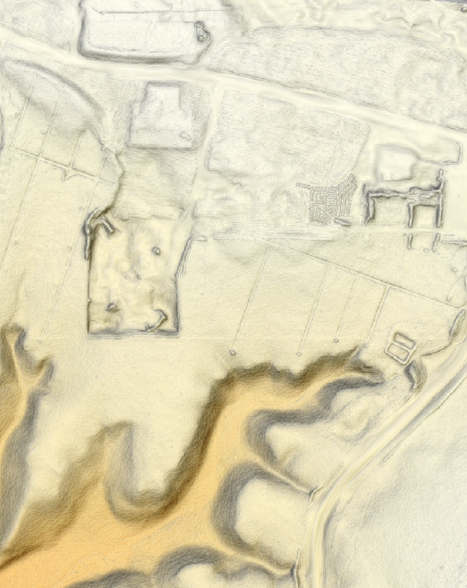
Archeological aerial surveys
High resolution aerial 2D and 3D mapping and modelling of archaelogical sites using a variety of sensor platforms.
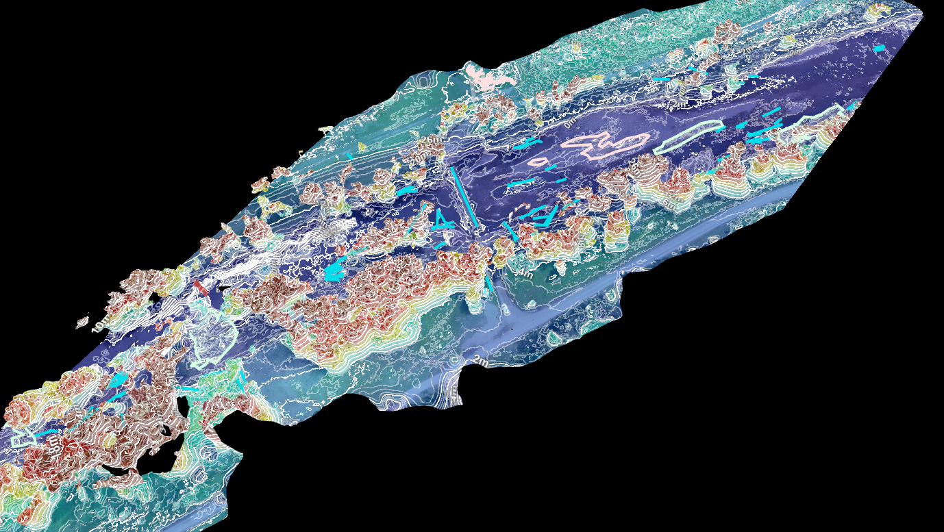
Utilising state-of-the-art LiDAR technology, J2 delivers ultra precise topographical and vegetation data, providing essential insights for a wide range of applications from environmental studies to urban planning. Our LiDAR services offer clients detailed 3D modelling and analysis, facilitating informed decision-making with accuracy and depth.
-
Asset inspections – LiDAR
High density 3D point cloud mapping of the physical environment using colourised LiDAR processing.
-
Environmental surveys
High resolution imagery for analysis of vegetation, habitat and wildlife surveys over large scale areas.
-
Archaeological aerial surveys
Ultra high resolution imagery for analysis of archaeological aerial surveys over large scale areas.
-
Disaster relief services
Ultra-high resolution imagery to support disaster resilience and recovery activities over large scale areas of operation.
J2’s service delivers high-resolution aerial 2D and 3D mapping and modelling, crafting a digital twin of your area of interest for in-depth analysis and planning. J2’s dynamic platform seamlessly integrates imagery and data from diverse sources, providing a singular, reliable point of reference to empower decision-making for command and control. Additionally, J2 creates Digital Terrain Models (DTM) and Digital Surface Models (DSM) to facilitate precise elevation assessments, with DTMs depicting terrain exclusive of vegetation and structures and DSMs including all surface objects for comprehensive topographical understanding.
-
Orthomosaic, Obliques and 3D Twins
Orthomosaic imagery is a detailed, accurate composite of the Earth’s surface, created by stitching multiple aerial images together. Unlike traditional aerial photos, these images are corrected for distortions, ensuring scale accuracy for precise measurements.
Oblique imagery consists of aerial photographs taken at an angle, typically between 30 to 45 degrees. This perspective offers a more natural and comprehensive view of terrain, structures and features, providing depth and detail that nadir imagery cannot achieve.
A 3D digital twin is a virtual model that replicates the physical attributes and spatial characteristics of real-world objects or environments. Created using remotely sensed imagery, it offers an interactive 3D representation of reality. This technology allows for advanced visualisation, simulation and analysis.
-
Common Operating Picture (COP) – development, input and maintenance
J2’s dynamic suite of capabilities and services seamlessly integrates imagery and data from diverse sources, providing a singular, reliable point of reference to empower decision-making for command and control.
-
Digital Models
- Digital Elevation Model (DEM)
- Digital Surface Model (DSM)
- Digital Terrain Model (DTM)
- Normalised Digital Surface Model (nDSM)
- Digital Terrain Slope (DTS)
- Digital Terrain Aspect
- Digital Terrain Slope/Aspect
- DEM Hillshade
- DSM Hillshade
- Individual Tree Segmentation
- Individual Tree Detection (ITD)
- Individual Tree Segmentation (ITS)
- Canopy Height Model (CHM)
- Foliage Cover Model (FCM)
Our services encompass a meticulous analysis of diverse imagery sources, as well as LiDAR and geospatial information, to deliver actionable insights and intelligence for informed decision-making. We provide comprehensive support for Geographical Information Systems (GIS), catering to both in-house and external needs. Additionally, our approach is augmented by AI-driven imagery analysis, significantly enhancing the speed, precision, and scope of our analytical capabilities to support critical operational requirements.
-
Imagery analysis
The detailed analysis of imagery from various sources to provide insights and intelligence reports and products for decision making purposes.
-
LiDAR analysis
The detailed analysis of LiDAR 3D point clouds from various sources to provide insights and intelligence reports and products for decision making purposes.
-
Geospatial analysis
The rigorous analysis of geospatial information from various sources to provide insights and intelligence reports and geospatial products for decision making purposes.
-
Geographical Information Systems (GIS) services
The provision of and support for GIS – both organic and external.
-
Artificial Intelligence (AI)-supported imagery analysis
Training and application of AI-driven imagery analysis in conjunction to enhance the speed, accuracy and scale of analysis.
J2 deploys drone teams adept in search and rescue (SAR) operations, employing military-grade command and control strategies to deliver crucial intelligence swiftly. The service includes provision of live video feeds from drones via GSM and satellite links, ensuring real-time data is available for immediate decision-making. Additionally, J2 are developing the capability for long-range (BVLOS) drone delivery to bolster humanitarian aid efforts, aiming to extend our reach and impact significantly.
-
Search and Rescue (SAR) support
The employment of drone teams to support the search and rescue (SAR) operations, leverage military small teams, command and control principles to provide timely intelligence.
-
Live drone and multi-platform video feeds to command centres
Provision of live video feeds from drone platforms via GSM and satellite links to provide real time information for decision making purposes.
-
Humanitarian aid delivery – Beyond Visual Line of Sight (BVLOS)
Provision of long range (BVLOS) drone delivery support to humanitarian aid. Note: While J2 is cleared for conducting BVLOS operations with CASA, the last mile delivery is still under development.
-
Common Operating Picture (COP)- development, input and maintenance
A dynamic platform that fuses imagery and data from multiple sources to provide a single point of reference for appropriate command and control elements to make decisions.
-
Scouting surveys
J2 deploys small teams capable of operating in remote and austere environments. Utilising our advanced platforms and analysis processes we create intelligence packages to inform the planning and staging of larger teams intending to establish activities in a prospective area of operations.
